Super Interactive Maps for WordPress

$3.90

Original Product
Lifetime Updates
Unlimited Website Usage
Safe & legal under GPL
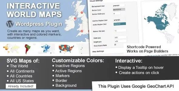
Super Interactive Maps for WordPress is an advanced and easy-to-use interactive mapping plugin that allows you to create fully customizable vector maps for your website. Built with Google Geochart API, it enables you to display geographic data in a visual and engaging way — perfect for showcasing company branches, regional statistics, travel destinations, or customer distributions.
Key Features of Super Interactive Maps:
-
Google Geochart Integration
Build dynamic maps with reliable performance. -
Interactive Regions & Markers
Highlight locations, countries, or continents. -
Custom Colors & Tooltips
Personalize map designs with hover effects and pop-ups. - Multiple Map Types
Choose from world, regional, or country-specific maps. -
Easy to Embed
Insert maps anywhere with simple shortcodes. -
Lightweight & Fast Loading
Optimized for speed and performance. -
Translation Ready
Works seamlessly with multilingual websites.
Related products